|
|
Post by Admin on Dec 18, 2017 20:54:04 GMT
Expansion TectonicsHi James, David, Gene & Louis. Louis says he favors ET, so I added him to the group. Bruce Nappi said he'll probably let me be a "peer reviewer" if I want to, so as a potential reviewer, I want to let all of the Earth Theorists know what I think may be necessary to pass the review process as a high-ranking theory. Science is never completed, I guess, so not passing the review process may just mean more info or better reviewers are needed. I have asked regarding Expansion Tectonics, do you agree that this is what's needed to definitively prove the model? _1. geologic cross-sections from opposite shores of the Pacific that closely match outlines & rock types & unique fossil types, similar to the matches of opposite shores of the Atlantic; _2. even if the Pacific shores do match, the opening of the ocean basins could have been caused by the Earth having changed shape from oval to spherical, as Fred Juenemann theorized; so ET must also rule out such a change in Earth's shape. A few months ago I asked James this version of the first question: [Q2] Do the shapes and (rock and fossil type) contents of opposite continental shores of all oceans match very precisely? He answered, which I'll quote below. But if anyone thinks something else would be a better test for ET, let me know. First, I have some info. James, Dr. Choi said your previous submission to NCGT was not accepted at the time because of an unrecognized cause of expansion or something like that. Since Louis is an editor of NCGT, I think, and favors ET, he may like to help get a paper of yours accepted by NCGT, as he has also written favorably there about David Noel's ET work. Personally, I don't think a cause of expansion is necessarily needed to suggest that expansion is likely, because we don't usually need to know the exact cause of an event to determine that the event did occur. James, Bruce Nappi had said you recommended that CNPS contact AIG for possible collaboration. I emailed them at AIG@aig.org.au, saying you had recommended possible collaboration with CNPS, but they never replied. Do you have an email address of anyone else there that I should try? Okay, now below is James' long answer to the question about matching shapes and contents of opposite continental shores, especially of the Pacific. I added the <<subject titles>> for most of the paragraphs to help me see at a glance what each paragraph covered. I read lately that Alfred Wegener wrote a book in which he showed that the rock and fossil types on opposite shores of the Atlantic matched very well. I've seen a little of that data since a few years ago, which seems impressive, but I haven't seen detailed data yet. If anyone knows where such detailed data is, please let me know. I think geologic cross-sections would be about the most definitive, but I don't know if that's included in any of the Wegener data. Does anyone know where to get such cross-sections, especially for the Pacific shores? In James' answer below, I don't understand the significance or meaning of matching mid-ocean-ridges in the second paragraph. James, or you others, is any of the info in the answer below close to the value of the detailed cross-sections data? Or can you show the actual data that is talked about below? I'll try to copy this to the official CNPS forum as well as to my separate CNPS forum at CNPS.boards.net . Thanks everyone for any help with this. _<<Sources>>This question is the basis of my research into Expansion Tectonics and my publications are testament to the integrity of utilising modern global data to quantify an increasing Earth mass and radius proposal. Expansion Tectonic spherical modelling studies use the published bedrock Geological Map of the World map (1990) to constrain assemblage of both the oceanic and continental plates, along with an extensive range of additional modern global tectonic data from the various fields of geoscience. See: www.expansiontectonics.com for a comprehensive summary of Expansion Tectonics, along with an extensive range of data modelling studies and downloads. Spherical small Earth models of the Jurassic to present-day increasing radius Earth. Each small Earth model demonstrates that the seafloor crustal plate assemblage coincides fully with seafloor spreading and geological data and accords with the derived ancient Earth radii. Source: Maxlow, 1995. _<<Mid-ocean-ridges fit>> By progressively removing age-dated seafloor volcanic crust (coloured seafloor stripes in the above figure) from each of the small Earth models in turn, it is shown that the global plate fit-together along each of the mid-ocean-ridge plate margins achieves a better than 99% global fit for each model constructed. This unique fit-together is considered to empirically confirm that post-Triassic small Earth geological modelling is indeed a viable process. This experiment further demonstrates that all remaining continental crusts assemble as a complete Pangaean Earth at approximately 50 percent of the present Earth radius during the late-Permian—around 250 million years ago, see figure below. At that time the ancient Earth was completely covered in continental crust and a network of relatively shallow continental seas coincided with low lying sedimentary basins. _<<Ancient continental seas & ruptures>> Permian Pangaea small Earth crustal assemblage. The model shows the ancient coastline distribution (blue lines) as well as the ancient Tethys, Iapetus, and Panthalassa Seas (blue shaded areas) forming part of a global network of continental seas. The figure also shows the locations of continental rupture commencing in the north and south Pacific and Arctic Ocean regions to form the modern oceans. _<<Crustal stretching>> Quantification of an increasing radius Earth back to the early-Archaean requires an extension of the fundamental cumulative seafloor volcanic crustal premise to include continental crusts. Continental crust is reconstructed on pre-Triassic small Earth models by considering the primary crustal elements: cratons, orogens, and basins. In order to complete the pre-Triassic small Earth modelling, consideration was given to an increase in Earths continental surface area occurring as a result of crustal stretching and extension within an established global network of continental sedimentary basins. [Note scale bar in each image]. _<<ET Models>> Spherical Archaean to future small Earth geological models. Models range in age from the early-Archaean to present-day, plus one model projected 5 million years into the future. Source: Maxlow, 2001. _<<Model mass removal>> Moving back in time, this crustal extension is progressively restored to a pre-extension, pre-stretching, or pre-rift crustal configuration by simply removing young sedimentary and intruded magmatic rocks and reducing the surface areas of each of the sedimentary basins in turn, consistent with the geological data shown on the Geological Map of the World. By removing all basin sediments and magmatic rocks, as well as progressively reducing the surface area of each sedimentary basin in turn, an ancient primordial small Earth with a radius of approximately 1,700 kilometres, or 27 percent of the present Earth radius, is achieved during the early-Archaean—4,000 million years ago, see figure below. This primordial Earth comprises an assemblage of the most ancient Archaean cratons and Proterozoic basement rocks, all other rocks are simply returned to their places of origin—albeit back to the mantle or back to the ancient lands. _<<Model of original Earth>> The primordial Archaean small Earth model showing the assemblage of ancient early-Precambrian continental crusts. Cratons are shown as pink and red, Proterozoic orogenic rocks are shown as khaki and the location of the present-day Antarctic and Greenland ice-sheets (covering Precambrian crustal rocks) are shown as off white. The ancient equator is shown as a horizontal red line and the poles are shown as red and blue dots. Ancient remnants of each of the present-day continents are outlined in black. Source: Maxlow, 2001. _<<Simple predictable expansion process>> The unique assemblage of all continental and seafloor crustal fragments on small Earth models demonstrates that an increasing radius Earth, extending back 4,000 million years to the beginning of Earth’s geological past, is indeed viable. What the full range of Archaean to present-day small Earth models also demonstrate is that, rather than being a random, arbitrary, amalgamation-dispersal-amalgamation cyclical crustal forming process as we are currently led to believe, crustal development on an increasing radius Earth model is shown to be a simple, evolving, and predictable crustal process. _<<Paleomagnetic data>> The application of palaeomagnetic data to small Earth models shows that all ancient magnetic poles cluster as unique diametrically opposed north and south poles—as they should—and similarly, plotted palaeolatitude data coincide with and quantify predicted climate zones on each small Earth model constructed. Similarly, additional geographical and biogeographical information aptly quantify the location of these ancient magnetic poles, equators, and climate zones as determined from unconstrained palaeomagnetic pole and latitudinal data. _<<Continental seas became oceans?>> When published coastal geography is plotted it is shown that large, conventional, Panthalassa, Iapetus, and Tethys Oceans are not required on a smaller radius Earth. Instead, this same coastal geography defines the presence of more restricted continental Panthalassa, Iapetus, and Tethys Seas, which represent precursors to the modern Pacific and Atlantic Oceans and emergent Eurasian continents respectively. From this coastal geography the coastal outlines and emergent land surfaces on each small Earth model is then shown to define the ancient Rodinia, Gondwana, and Pangaea supercontinents and smaller sub-continents. The coastal geography demonstrates an evolutionary progression and development of each of the ancient seas and supercontinents throughout Earth history which is shown to be intimately related to changes in sea-level, changes to the outlines of continental sedimentary basins, changes incurred during crustal mobility, and changes to sea-levels once the modern oceans opened to the present-day. _<<Expansion & evolution>> The timing and development of these ancient continental seas and supercontinents, along with formation of the modern continents and oceans, is then shown to be the prime cause for evolution of all life forms on Earth. The ancient continental seas, in particular, provided an ideal setting for the primitive Precambrian microbe’s effectiveness as nurseries of evolution and to markedly drive subsequent evolutionary change in all life forms. _On each of the small Earth models, warm sea waters during much of the Palaeozoic (550 to 250 million years ago) extended from equatorial regions through to the North Polar Region allowing newly evolved species to readily colonise and populate throughout each of the interconnected ancient Tethys, Iapetus, and Panthalassa seaways. This distribution of warm seas also limited the presence of a polar ice cap in the North Polar Region and restricted the presence of ice to the exposed Gondwanan South Polar Region throughout much of that time. The distribution of warm seas enabled stable carbonate shelf environments to develop adjacent to the ancient lands, along with deeper anoxic basins further away from the coastlines. The extensive algal mats and early reefal mounds present throughout much of the Precambrian (prior to 550 million years ago) eventually gave way to predation and bioturbation, and planktonic life forms were able to readily spread throughout the deeper seas. _Similarly, extinction of species is shown to be a by-product of sea-level changes, disruption to the distribution of established seas, and the inability of species to keep pace with these environmental changes. It is further considered that evolution of species during these ancient times was subsequently driven by the need to survive amongst these ever increasing changes to the Earth and environment. _During the end-Permian continental breakup and opening of the modern oceans (250 million years ago), the existing intercontinental migration and dispersal routes of the various terrestrial and marine species were then disrupted, enabling species endemic to the various regions to interact and extend their boundaries with time. From the distribution of climate-dependent rocks and animal species it is also shown that these distributions coincide precisely with climatic zones anticipated on an increasing radius Earth. It is similarly shown that these climatic indicators display a distinct latitudinal zonation paralleling the ancient equator, suggesting that an inclined Earth rotational axis inclined to the pole of the ecliptic was well established during at least the Palaeozoic Era and has persisted to the present-day. _<<Extinctions from rising seas>> On an increasing radius Earth the small Earth modelling studies show that, during early-Palaeozoic to present-day times there have been a number of drastic and prolonged changes to sea-levels which coincide with the five major extinction events. On these models, major changes in sea-levels are shown to occur as a result of separation or merging of previous ancient continental seas, as well as onset of geosynclinal activity and orogenesis, breakup of the ancient supercontinents, opening of the modern oceans, and draining of the ancient continental seas. Depending on the severity of these events, it is considered that sea-level changes may have also adversely affected regional to global-scale climate, as well as ocean-water circulation patterns, species habitats, and the type and location of sedimentary deposition. _<<Summary>> In summary, it is concluded that the extensive modern global tectonic evidence now available along with the empirical modelling studies presented in this research more than adequately demonstrate that an increasing radius Earth is a viable and demonstrable tectonic process. From a geological perspective, at no point has any fundamental physical law been violated. The commonly held presumption that Earth radius has remained constant throughout time was simply removed and instead, the Earth was allowed to tell its own story.
|
|
|
|
Post by Admin on Dec 18, 2017 21:25:28 GMT
[LK: DN re ET & Cagle]Expanding Earth On 18 November 2017 at 11:31, lloyd kinder <lkindr@yahoo.com> wrote: _Hi David. One of the NCGT members sent me info about your new website and model, so I checked it out. I don't know if you've heard of Charles Cagle's model, but his was similar. I heard of it about 20 years ago. I just put together some info on it at www.thunderbolts.info/forum/phpBB3/viewtopic.php?f=10&t=1184&p=122283#p122283 -- Have you heard of it? He had an electromagnetotoroid model that he used to explain expansion and non-expansion. Do you think there's anything useful in his model for yours? You may notice in that thread that I mentioned Michael Mozina's similar theory for the Sun, which is sort of based on Oliver Manuel's Iron Sun model. _Would you like to join our CNPS Special Project of discussions of Earth Models? CNPS is at naturalphilosophy.org and James Maxwell is a member. I suppose you two are in contact. CNPS wants to improve scientific discussion and publication process and supports alternatives. - Good Day. Lloyd Kinder [DN: re ET & Link]Re: Expanding Earth Saturday, November 18, 2017 12:25 AM From: "David Noel" <davidn@aoi.com.au> To: "lloyd kinder" <lkindr@yahoo.com> _Hi Lloyd, many thanks for your email and the link to Charles Cagle's models, which I'll enjoy checking out. Yes, do write me in for the "CNPS Special Project of discussions of Earth Models". Just in the last few months I've put out a new article on Earth Expansion, I don't know if that was what you meant by my new model. It's at: EP303: The Earth-Expansion Model Part B: Answers to A Hundred Puzzles < www.aoi.com.au/EP/EP303.htm > _This article does refer to James Maxlow's work, and has quite a lot on models. _Keep up the good work -- David Noel 2017 Nov 18 [GE: ET, Growing Matter]Re: CNPS Special Project Report & Requests Saturday, December 16, 2017 6:22 AM From: "Eugene Ellis" <GeneAEllis@msn.com> To: "lkindr@yahoo.com" <lkindr@yahoo.com> "hallad1257@gmail.com" <hallad1257@gmail.com> "davidn@aoi.com.au" <davidn@aoi.com.au> "jweirich@psi.edu" <jweirich@psi.edu> "rfarrar.lpool@virgin.net" <rfarrar.lpool@virgin.net> "dougettinger@verizon.net" <dougettinger@verizon.net> "donbriddell@fieldstructure.org" <donbriddell@fieldstructure.org> "servant@wt.net" <servant@wt.net> "mike@newgeology.us" <mike@newgeology.us> "james.maxlow@bigpond.com" <james.maxlow@bigpond.com> "leybourneb@iascc.org" <leybourneb@iascc.org> "irfantaner@hotmail.com" <irfantaner@hotmail.com> "bhatmi@hotmail.com" <bhatmi@hotmail.com> "jcasey@ievpc.org" <jcasey@ievpc.org> "lev.maslov@cccs.edu" <lev.maslov@cccs.edu> "giovanni.gregori@idasc.cnr.it" <giovanni.gregori@idasc.cnr.it> "louis.hissink@bigpond.com" <louis.hissink@bigpond.com> "kubota@env.sc.niigata-u.ac.jp" <kubota@env.sc.niigata-u.ac.jp> "perm@must.edu.mn" <perm@must.edu.mn> "ninapav@mail.ru" <ninapav@mail.ru> "dp@davidpratt.info" <dp@davidpratt.info> "Karsten.storetvedt@uib.no" <Karsten.storetvedt@uib.no> _Lloyd and all, This video on S. W. Carey was posted recently. I got it from a friend a few days ago. www.youtube.com/watch?v=Othb0xsvZb4&feature=youtu.be_Gene
|
|
|
|
Post by Admin on Jan 1, 2018 20:02:39 GMT
Invitation to Tectonics Special Project John D. Taylor Dec 29 9:13 PM _The genus Pseudotsuga has species in the west coast of America and the western pacific rim _And the palmatum group of maples genus, Acer; These are living groups and can be explained by ocean current for present day ocean currents but not for what would have been past ocean currents with Plate tectonics to match fossil records _Acer circinatum is the only species living outside Asia en.wikipedia.org/wiki/Acer_circinatumptolemy1022 Dec 30 3:10 PM _Loyd wrote, "I'm open to other possible proofs as well, but matching Pacific shores seems to me to be likely the best and doable. Agree?" _ Granite foundation seas exist along east coast of Asia and Australia. These were once part of the single continent, where all seas stood on granite foundations, instead of basalt like the modern abyssal seas. Billions of cubic kilometers of striated sedimentary rocks loaded with marine fossils exist only on granite foundations. These attest to the early earth, where the shallow seas stood only on the same basement as the single continent. Thus, the shores across the Pacific (the earliest modern ocean, except for the Mediterranean inland sea), will not mesh. _Victor James Maxlow Dec 30 9:58 PM _Guys, I have reposted my attached book manuscript detailing the formation of the ancient supercontinents and modern continents. This modelling is based on global geological mapping, not speculation. For a non-geologist you can speculate as much as you like because nobody will know any better, but you can’t fool me. Fact is what drives the earth. _Cheers, James James Maxlow Dec 31, 12:33 AM _Facts = global observational data (GOD) If your speculation is not supported by empirical global observational data (geology) then it is still mere speculation. You can speculate as much as you like petal but it doesn’t mean that you are correct or even come close to reality. Carl Strutinski Dec 31, 4:01 AM _We (in our group) all consider that the Earth grows, but are as different as possible in our positions as to how this happens. I, for instance, cannot accept James's assumption that orogeny merely results by modification of surface curvature and implied compression at discrete ruptures in a primordial crust. I do not even see the opportunity for those compressive forces to occur. Compression has far less importance in orogeny as usually assumed (except for the Himalayas). _What is more important to me is motion, horizontal translational motion. You cannot explain the most complicated geological structure on Earth - centred on the Indonesia area - by assuming interaction of "rigid" plates (PT position) or compression along boundaries resulted after rupture and curvature adaptation due to Earth growth (James). There must be something (e.g. the upper mantle) flowing underneath, similarly to the flow of glaciers. This is what physical and - still more - geological charts tell us about the region. To cite Carey: Geotectonics is simpler than we thought, the gross structures stare naked from the world physical chart and things really are what they look like. _In SE Asia deformation of the crust is extreme in plan-view and requires a substratum of particularly weak, deformable and flowing or creeping upper mantle. Deformation of the crust is linked here not with compression and crustal thickening like in the Himalayas but with advanced crustal thinning. However, along the transcurrent systems operating throughout the region folding and crumpling of rocks can take place simultaneously with thinning. _And as regards the role of Australia and its northward migration due to the growth of the Southern Ocean: it is of course a rigid piece of crust that forced the Indonesian crust to form the Banda loop (creeping mantle from underneath forced into a whirl). _For visual illustration I attach the structural map of SE Asia. _Carl James Maxlow Dec 31, 2017 _Actually, Australia is moving south away from SE Asia. If you have spent as much time exploring outback Australia as I have you will know that the ancient sediments are carbonate-rich which means equatorial latitudes, not polar latitudes as PT insists. This is also substantiated by geophysics where the ancient equator is known to have been located in South Australia and the Northern Territory during the Precambrian (i.e. Australia was orientated north-south as my modelling shows, rather than east-west as it is now). As well as this the weathering history has been one of warm tropical climates (at least 60 million years’ worth) which has given rise to deep weathering (as much as 600m at Telfer Gold mine) and extensive laterite chemical weathering of the soils and rocks (throughout Australia). This is substantiated by hold-over tropical species of palms, pines, ferns, etc., that still grow in remote pockets throughout Australia. Over the past 20,000 years there has been a progressive drying of the interior and increasing desertification, none of which is suggestive of Australia migrating out of polar regions into tropical regions. Neal Adams Dec 31, 2017 _James, ... though the north is moving away from Asia ,...the SOUTH is moving away from Antarctica,...because,..say it,..THE EARTH IS GROWING! (Look at the crustal Age Map! James Maxlow Dec 31, 2017 _Actually Neil, Antarctica is moving south and is crossing the south pole in sympathy with opening of the southern ocean as the earth grows. Neal Adams Jan 1, 1:05 AM _James,...look at the crustal age map and at the SPREADING Antarctic ocean UNDER AUSTRALIA! In the last 60 Million Years the Antarctic Ocean has spread incredibly and Australia moves away WITH it! _Neal lkindr Jan 1, 2:40 PM _ Opposite Shores of the Pacific _Hi Everyone. I copied some of the replies to my message "Invitation to Tectonics Special Project" and I posted them on a private forum at cnps.boards.net/post/93/thread_John D. Taylor Dec 29 9:13 PM said: "_The genus Pseudotsuga has species in the west coast of America and the western pacific rim "_And the palmatum group of maples genus, Acer; These are living groups and can be explained by ocean current for present day ocean currents but not for what would have been past ocean currents with Plate tectonics to match fossil records "_Acer circinatum is the only species living outside Asia en.wikipedia.org/wiki/Acer_circinatum " _Thanks, John. That's a start. _ptolemy1022 Dec 30 3:10 PM said: "_Loyd wrote, "I'm open to other possible proofs as well, but matching Pacific shores seems to me to be likely the best and doable. Agree?" "_ Granite foundation seas exist along east coast of Asia and Australia. These were once part of the single continent, where all seas stood on granite foundations, instead of basalt like the modern abyssal seas. Billions of cubic kilometers of striated sedimentary rocks loaded with marine fossils exist only on granite foundations. These attest to the early earth, where the shallow seas stood only on the same basement as the single continent. Thus, the shores across the Pacific (the earliest modern ocean, except for the Mediterranean inland sea), will not mesh. "_Victor" _Thanks, Victor. James guessed that I'm not a geologist and that's my guess too. But I'm learning. I didn't realize that some of the former Pacific shores are on the seafloor. Can anyone tell me the best places to find the outlines of the "Granite foundation seas ... along east coast of Asia and Australia"? Does everyone here agree on those outlines as Pacific "shores" or plate boundaries? Are the trenches the boundaries? Have any ocean drilling projects gotten any drill cores from the area of granite? If so, where can the data from such cores be found? Thanks for any help. _Lloyd Kinder Carl Strutinski Jan 1 2:49 PM _James, Australia was at low latitudes in the southern hemisphere at about the beginning of the Triassic. Some Alpine facies in Timor and in Papua New Guinea attest to this. In my present opinion it was located east of India and its eastern border may have been close to Central America. This location is more to the south than you suppose. My assumption is mainly based on the idea that Papua New Guinea belonged to the equatorial globe girdling Alpine Himalayan chain and that the continuation to the East, beyond the Pacific, can be traced through Guatemala-Cuba-Haiti ... into Eurasia. _With the onset of spreading NW of Australia during the Jurassic, Australia began to move relatively to the south (or India to the north), then to the east (the Central Indian Ridge began its activity) and finally to the north or northeast (due to spreading along the Southeast Indian Ridge). However, all these movements took place on a growing Earth and the directions assumed may not correspond exactly to reality, because we are tempted to consider them in relation to the present poles. As there is presently no spreading ridge between SE Asia and Australia I cannot follow your reason that "Australia is moving south away from SE Asia". Theoretically one could also consider that both SE Asia and Australia are moving south, only that in this case the velocity of SE Asia is faster. However it seems to me that oceans in the southern hemisphere are broadening faster than those in the northern hemisphere, which should support the idea that Australia is relatively moving north or at least in a stagnant position relative to the poles. _Carl Michael Clark Jan 1 6:06 PM _Do a Google search of Zealandiam the continent East Southeast of Australia; that is about 1/3 of the Surface Area of Australia. _There are continental crustal blocks submerged at various locations scattered over the Pacific. Smaller continents, and crustal blocks usually end up submerged then covered with sediment. _The Pacific Spread started sooner, and spread farther than the Atlantic Spread, so blocks got ripped off and sank. _Cook a glass pan of brownies, and while they are still warm, rip them apart, and see what happens at the edges. _Then do the same with another pan, but let them cool longer, and rip them apart slowly, and see what happens. _Mike Clark RE: CNPS: TABLE TO COMPARE EARTH THEORIES Monday, January 1, 2018 8:00 PM From: mike@newgeology.us _FYI Earth's continental crust averages 35 km thick, and of that only an average of 1.8 km is sedimentary rock. Most of the rest is granite, which is why it has an average density of 2.7 gm/cm3. The conventional view is that formation of continental crust began shortly after differentiation, about 4 billion years ago, and has continued growing since it floats and is not recycled. Thus most of it is younger than the Archean 2.4 billion years you note. _Recent geodetic measurements show that the Earth is not expanding. _It makes no sense to say that the presence or absence of glaciation is due to the presence of a continuous land mass or sea water below an ice sheet. _Mike Fischer Monday, January 1, 2018 8:52 PM From: "James Maxlow" <james.maxlow@bigpond.com> 3 Files 962KB _The answers that I gave to Lloyd’s questions below are from my own observations and research into expansion tectonics plus my own experience as a qualified geologist (retired). _[Re granite crust] This is a simplistic view of crustal development which is tainted by conventional plate tectonic assumptions. On an expansion tectonic earth (Neal read that as Growing Earth) formation of continental crust began at 4000 million years ago because surface temperatures were low enough for the various minerals making up the rocks to crystallise. You cannot have crust if it doesn’t crystallise and you cannot date rocks if they have not crystallised and been preserved intact. Bear in mind that sediments are derived from the weathering and erosion of pre-existing rocks, so the pre-existing rocks must be older than the sediments. _[Re] Recent geodetic measurements show that the Earth is not expanding. Geodetic measurements are constrained to a constant radius earth model. Geodesists do this by tweaking the maths to reflect on the assumption that earth radius is constant. That is why “when Robaudo and Harrison first established a “...global geodetic network” their calculations gave “...a Root Mean Squared value of up-down [variation in Earth radius] motions of over 18 mm/year.” In other words, the Earth was found to be potentially increasing in radius by up to 18 millimetres per year. Robaudo and Harrison “...expected that most… stations will have up- down motions of only a few mm/year,” and they went on to recommend that the vertical motion “...be restricted to zero, because [they considered that] this is closer to the true situation than an average motion of 18 mm/year.” Since then, the mathematical formulae and applied correction parameters attributed to this space geodetic data have been extensively refined which has enabled all perceived errors to be statistically meaned out to zero, precisely as recommended by Robaudo and Harrison.” (extract from my book.) _[Re glaciation] You misunderstand. A polar ice sheet only occurs within the north and south polar regions. My modelling studies (see attached figures) show that Gondwana covered the south polar region throughout the Precambrian times and hence, during the 5 main glacial periods, had a relatively stable ice sheet. In contrast, the north polar region was covered by the Tethys Sea, which enabled warm equatorial currents to flow into the polar region and hence the ice sheet, if present, was seasonal or absent – hence the seasonal effects in the Arctic Ocean ice cap. I am not saying that glaciation is due to the presence of a land mass, all I am saying is that if a polar region has a land mass during the 5 major ice ages then it will have a stable ice sheet, and vice versa for the seas. Why periodic ice ages occur is unknown, but, as I speculate in my manuscript, the periodicity of the ice ages approximates the 226 million year galactic cycle (the time it takes for the solar system to travel round the galactic centre) which may suggest a galactic winter/summer seasonal effect. Tuesday, January 2, 2018 4:35 PM From: "lloyd kinder" <lkindr@yahoo.com> To: mike@newgeology.us "'lloyd kinder'" <lkindr@yahoo.com> "James Maxlow" <james.maxlow@bigpond.com> _At the last post on my Shock Dynamics thread at cnps.boards.net/thread/28/prove-shock-dynamics I mentioned some of the Kola Borehole data, which says a lot of the strata there are sedimentary and metamorphosed granite, so it looks like the continents could be called sedimentary/granite. The world's 3 deepest boreholes are at the Kola in northern Russia (7mi.), southern Germany (5mi.) and Oklahoma (6mi.). Both of the European boreholes are said to have a lot of fractured rock, so I wonder how the fracturing would have occurred. I don't see info yet on the Oklahoma borehole regarding fracturing, but high pressure is mentioned, i.e. 25,000 psi. - Good Day. Lloyd James Maxlow Jan 1 6:00 PM _Attached are a few images of Australia and the various oceans to mull over. Prior to the Triassic Australia straddled the equator and was predominantly located in the northern hemisphere. India, in contrast to what you and plate tectonics say, was located against west Antarctica, not Australia. This is all substantiated by palaeomagnetic pole data which was used to located the poles and equator. Carl Strutinski Jan 2 1:21 AM _James, I do not have much confidence in paleomagnetic pole data calculated by people convinced by the non-growing Earth assumption. And on geological grounds I cannot agree with your position that before spreading in the Indian Ocean Indochina lay near southwestern Australia as your images show. Indochina was a labile zone within the Alpine geosyncline already before the Jurassic whereas Western Australia was a craton. And thus the opposing continental piece of SW Australia had to be also a cratonic zone. James Maxlow Jan 2 5:46 PM _Rightly so Carl. In my book manuscript I devote an entire chapter to discussing the limitations of palaeomagnetics constrained to a constant radius earth. I then modify the conventional palaeomagnetic formula to adapt them to an increasing radius earth model. Using these modified formula all magnetic poles plot as diametrically opposed north and south poles-as they should do. The attached figures show the north and south pole locations derived from the modified formula using the international palaeomagnetic dataset of McElhinny & Lock, 1996, and Pisarevsky, 2004. |
|
|
|
Post by Admin on Jan 4, 2018 9:10:05 GMT
____<<~4 Ga & 250 Ma [CRUST from:] Cooling Basalt/Granite & Expansion Basalt>> ____<<~3.9-0 Ga [STRATA from: Shallow Seas Deposition?]>> ____<<~2Ma [MOUNTAINS from:] Uplift from Increasing Radius Curvature>> ____<< >4 Ga [EARTH from:] Nebular Hypothesis Gravitational Accretion>> RE: Do I have your model right? Wednesday, January 3, 2018 8:27 PM From: "James Maxlow" <james.maxlow@bigpond.com> _Hi Lloyd, I have been mulling over your questions etc. but don't feel like I am getting through. Firstly, while I am tagged with Expansion Tectonic theory, the research that I present in my books and current manuscript is focussed on modelling factual global tectonic data independently of any preferred theory or concept. The research has been totally focussed on letting the data tell its own story and hence is empirical science. My emphasis to the group has been, although I don't always get it across to them, that any theory must be compatible with the empirical modelling data. The fact that this empirical modelling favours Expansion Tectonics is therefore very supportive of this theory. Secondly, geology is not cut and dry, as you appear to be attempting to portray. None of your answers to the questions below are correct, as again attested by the global data modelling, so I will go through and reword them for you. Regarding glaciation, you should be able to piece together something from the postings I have sent recently i.e. there have been five major glacial events. The following is an extract from my manuscript. _"There have been at least five major ice ages in the Earth's geological past, referred to as the Huronian, Cryogenian, Andean-Saharan, and Karoo ice ages, and the current Quaternary glaciation. Outside these ages, the Earth was ice-free even in high latitudes. Glacial related rocks from the earliest, well established, Huronian ice age formed around 2.4 to 2.1 billion years ago during the early-Proterozoic Eon. The next well-documented Cryogenian ice age, suggested as being the most severe, occurred from 850 to 630 million years ago during the late-Proterozoic. It has been suggested by others that the end of this ice age was responsible for the subsequent late-Proterozoic and Cambrian explosion of life forms, athough this suggestion is controversial. The Andean-Saharan ice age occurred from 460 to 420 million years ago during the late-Ordovician and Silurian Periods. The Karoo ice age occurred at intervals from 360 to 260 million years ago in South Africa during the Carboniferous and early-Permian Periods. Correlatives are also known from Argentina within the ancient supercontinent Gondwana. _The current ice age, the Quaternary glaciation, started about 2.58 million years ago during the late-Pliocene when the spread of ice sheets in the Northern Hemisphere began, although an ice cap began forming much earlier on Antarctica some 33 million years ago. Since then, the Earth has seen cycles of glaciation with ice sheets advancing and retreating on 40,000 to 100,000 year time scales. The Earth is currently in an interglacial period and the last glacial period ended about 10,000 years ago. All that remains of the present glaciation is the Greenland and Antarctic ice sheets and smaller glaciers such as on Baffin Island, Canada, and various mountain glaciers." _Okay, question 1C. How and when did the largely granitic/sedimentary continents and the largely basaltic ocean basins form? ____<<~4 Ga & 250 Ma [CRUST from:] Cooling Basalt/Granite & Expansion Basalt>> The largely granitic/sedimentary primordial (supercontinental) continental crusts initially formed around 4000 million years ago. The primordial granitic cratonic crusts were formed first once surface cooling was low enough to allow crystallisation of the primitive minerals and rocks. As the surface area increased during increase in earth radius the primitive continental sediments accumulated in low-lying continental basins. The oldest dated sediments are around 3.9 billion years old. Accumulation of continental sediments continued throughout the Precambrian and Palaeozoic times until the continental crusts ruptured to form the modern continents and opened to form the modern seas at around 250 million years ago. The basaltic ocean basins commenced opening from around 250 million years ago and have continued opening and increasing in surface area to the present. _The answer to your question then is that, on an increasing radius Earth, the modern continents have only existed in their current form since breakup of the ancient Pangaean super-continental crust commenced some 250 million years ago. These modern continents represent the fragmented remains of the ancient Pangaea supercontinental crustal shell. Fragmentation and breakup of Pangaea occurred because the ability of the supercontinental crusts to continue to stretch and extend during on-going increases in Earth surface area was exceeded during late-Permian times. Once crustal stretching was exceeded the Pangaean supercontinental crust then ruptured, broke apart and fragmented to form the modern continents and opened to form the intervening modern oceans. Opening of the modern oceans then exposed the basaltic mantle rocks to form the modern, largely basaltic, ocean basins, i.e. the modern ocean basins represent exposed and quenched mantle rocks. _2S. How and when did sedimentary rock strata form? ____<<~3.9-0 Ga [STRATA from: Shallow Seas Deposition?]>> Sediments are the by-product of weathering and erosion of exposed pre-existing rocks. The oldest known sedimentary rock is dated at around 3.91 billion years old. Sedimentary rocks occur throughout earth history and are continuing to form today. Throughout earth history though the type and distribution of sediments have varied considerably. Sediments older than 250 million years (pre-breakup) are all continental sediments while those younger than 250 million years are predominantly marine. _3M. How and when did mountains form? ____<<~2Ma [MOUNTAINS from:] Uplift from Increasing Radius Curvature>> This is an ambiguous question because it depends on accepted theory. In 2000, Ollier and Pain noted in their book on mountains that a distinction must be made between orogeny, which deals with the formation of fold belts, and uplift to form mountains. This distinction is not always clear in conventional tectonic usage. In their book Ollier and Pain showed that, in contrast to folding of rocks to form mountains, modern mountain building instead results from vertical uplift to form “plateaux”—large areas of relatively flat uplifted land surfaces—rather than from horizontal compression. _Ollier and Pain provided many examples from major mountain ranges throughout the world to show that most mountains are, in fact, relatively young (as young as ~2 million years) eroded plateaux, with very little to do with the earlier folding event, or events, as preserved in the rocks below the plateaux. These plateaux were seen as once been relatively flat, low-lying eroded surfaces, such as now seen along many continental margins. As a result of vertical uplift, the ancient rivers and streams of the time were then reactivated and new erosion surfaces proceeded to cut across older folded bedrock structures to form new plateaux and eroded escarpments. _4F. How and when did the Earth form? ____<< >4 Ga [EARTH from:] Nebular Hypothesis Gravitational Accretion>> Sort this one out yourself Lloyd. Increasing radius small Earth modelling studies show that the size of the early-Archaean Earth was around 27 percent of the present Earth radius—a similar size to the present Moon. At that time the entire primordial Earth crust comprised granite and volcanic rocks with very little sedimentary rocks and no large oceans. It is speculated from the crustal and mantle temperature studies of others that the pre-Archaean Earth—times older than 4,000 million years ago—may have been incandescent, that is, hot enough to remain molten without crystallisation to form a stable crust or dateable minerals and rocks. _In order for the primordial Earth, and by inference the Moon, to be incandescent during pre-Archaean times it is speculated that the Earth-Moon system was located much closer to the primitive young Sun than it is now. The very much reduced Earth-Moon size and mass existing at that time would insist that centrifugal forces and angular momentum would have been vastly different to what they are now and hence this suggestion may be plausible. By Archaean to early-Proterozoic times the Earth-Moon system may have then moved sufficiently far away from the influence of the Sun’s surface temperature and gravity to cool and form a stable primitive crust. Sufficiently far to also lower Earth-Moon surface temperatures enough to retain liquid water on the primitive Earth surface while still retaining a high residual geothermal gradient in the mantle. _During the distant pre-Archaean times—an indeterminate time span of maybe billions of years—it is further speculated that the Earth-Moon system may have also been originally combined as a single molten planet. By combining the volume of the present Moon and the volume of the early-Archaean Earth, the pre-Archaean Earth-Moon system is readily calculated to have been approximately 2,100 kilometres radius prior to separation. At, or sometime prior to 4,540 million years ago, the Earth and Moon may have then separated. It is envisaged that this separation occurred as a result of gravitational instability of the more basaltic molten surface layer of the primitive incandescent Earth-Moon, possibly as a result of a high rotational velocity and centrifugal forces, forming a double planet. This mechanism is described in conventional literature as fission of the Moon from the Earth’s primitive basaltic crust through centrifugal forces occurring during a period of high angular momentum of the Earth–Moon system. A high angular momentum and rotational velocity may again add support to the suggestion that the Earth-Moon system was originally located much closer to the primitive young Sun. _It is further speculated that, once separated, this double planet scenario would have originally comprised two bodies, the Earth and the Moon, of approximately equal size—around 1,700 kilometres radius—and in close proximity co-rotating around each other as they do today. Currently, the Earth and Moon are continuing to move further apart and are now separating at a measured rate of 38 millimetres per year. It is also feasible to consider that the Earth-Moon system is continuing to move further away from the Sun. This, more passive separation process, in contrast to a speculative impact event, may then go a long way to explain why the Moon is currently in synchronous, albeit retrograde rotation around the Earth, always showing the same face to the Earth. _Cheers James [[[Answers at cnps.boards.net/post/55/thread ]]]Thursday, January 4, 2018 3:04 AM From: "David Noel" <davidn@aoi.com.au> _Hi Lloyd -- -- My Earth-Expansion Model (described in EP302: The Earth-Expansion Model Part A: The Death of Plate Tectonics < www.aoi.com.au/EP/EP302.htm > and EP303: The Earth-Expansion Model Part B: Answers to A Hundred Puzzles < www.aoi.com.au/EP/EP303.htm >) is similar to James Maxlow's views, with the following exceptions. _1) In my view, there is nothing RAISING James' and Cliff Ollier's " plateau mountains", doomed to be eroded to form mountain ranges. Instead, they are areas of the Earth's surface left behind while surrounding areas SINK down relatively, due to Equilibration (described in How Seafloor Spreading affects the level of oceans and seas: The Expansion Equilibration Model < www.aoi.com.au/bcw/Seafloor/index.htm >). We agree that frictional forces acting along the junctions of Earth Domains (something like tectonic plates, though that term is a misnomer) are responsible for mountain ranges like the Rockies and Andes. _2) My model gives the REASON for Earth Expansion (See XT807: The Concore Model of planet and star interiors < www.aoi.com.au/Extracts/XT807.htm >), in contrast to other models. And this model doesn't involve any extra mass coming from anywhere. _3) My model also explains how and why earthquakes occur (Finally, the True Origin of Earthquakes < www.aoi.com.au/bcw1/Finally/index.htm >) and, in particular, the source of the immense energies involved. No other model that I know of explains this. _4) I also have a new model of how the Earth and other planets formed, quite different to the usual Planetary Protodisc idea (See P1: The Cosmic Smog model for solar system formation, and the nature of 'Dark Matter' < www.aoi.com.au/bcw1/Cosmic/index.htm >). This ties in very closely with the Concore Model in (2). _Cheers, David. |
|
|
|
Post by Admin on Jan 7, 2018 5:12:16 GMT
Re: Do I have your model right? Wednesday, January 3, 2018 5:07 PM From: "Eugene Ellis" <GeneAEllis@msn.com> _Lloyd, Below are my answers to your questions. It is hard to shorten them without losing meaning. _1C Continents formed ~ 750 MYA when the Earth’s radius was ~800 km. The cooled solid crust cracked forming various land masses. The cracks widened and lengthened forming the ancient seas and lakes (and eventually the continental shelves). The Pacific Ocean floor began expanding ~200 MYA. _2S Crustal cooling from the top down starting ~1400 MYA to present primarily caused layering. In addition, the elements in the layers are growing and heating. _3M Mountains likely formed ~220 MYA when 50% of Earth was heating and 50% was growing (heat + pressure) thereby increasing radius curvature, inducing crustal flattening, plus weathering. _4F 8-elements formed into a >800 km ball ~4500 MYA. _Gene [[[Answers at cnps.boards.net/post/55/thread ]]] ----- Original Message ----- From: lloyd kinder To: GeneAEllis@msn.com Sent: Wednesday, January 3, 2018 12:16 PM Subject: Do I have your model right? _Hi Gene. _I copied your recent message about your model here: nam04.safelinks.protection.outlook.com/?url=http%3A%2F%2Fcnps.boards.net%2Fpost%2F91%2Fthread&data=02%7C01%7C%7C6a811df22e984565763c08d552cdc98d%7C84df9e7fe9f640afb435aaaaaaaaaaaa%7C1%7C0%7C636505966156026356&sdata=FV8AIfJLMieRelZHy6339hskstE6gtbwhyqizjBswG0%3D&reserved=0 . _For the table to compare theories, I removed the question of glaciation. Here are what I have as simplified versions of your answers to the 4 remaining questions. Please let me know if I have anything wrong and how I should change the wording. _1C. How and when did the largely granitic/sedimentary continents and the largely basaltic ocean basins form? GM: ~200-0 Ma Ocean Basin Expansion & some Continental Expansion _2S. How and when did sedimentary rock strata form? GM: ~1.4-0 Ga Shallow Seas Deposition _3M. How and when did mountains form? GM: ~220-0 Ma Increasing Earth Radius Curvature _4F. How and when did the Earth form? GM: ~4.5 Ga Dark Matter Conversion ----- Re: Mathmatical Analysis of EE Plausibility Saturday, January 6, 2018 10:27 AM From: "Eugene Ellis" <GeneAEllis@msn.com> _Gene ----- Original Message ----- From: Bruce Nappi To: Eugene Ellis Sent: Saturday, January 6, 2018 10:03 AM Subject: Fwd: Mathmatical Analysis of EE Plausibility _Gene, Both Ray and Cameron have helped the Expansion Tectonics effort in the past, but it was only incidental. Something caught their interest related to other things they were working on. I've put them on cc: just so they will see this. _It is more important that we include Lloyd Kinder in this. Your theory of expansion, if it captures something going on throughout the universe, upsets ALL the apple carts of physics. Lloyd can best decide how to link this paper into the ET effort, as well as the new Project 2 references. _Thanks for this alert. _Bruce ----- Begin forwarded message: From: Eugene Ellis <GeneAEllis@msn.com> Date: January 5, 2018 2:35:06 PM EST To: "bnappi@a3ri.org" <bnappi@a3ri.org> Subject: Mathmatical Analysis of EE Plausibility _Bruce, It was noticed in the 6.2 Forum that Ray Gallucci and Cameron Ribigsol did some analysis and computations based on James Maxlow's work. _I wonder if you could instigate a similar evaluation on the attached moon paper [[[? ? ?]]] that includes Earth data and some supporting Earth-moon (past distances) calculations. If there is any interest to including the sun, the link to that paper is: ionic-expanding-earth.weebly.com/ionic-growing-sun.html----- Fw: Mathmatical Analysis of EE Plausibility Saturday, January 6, 2018 10:56 AM From: "Eugene Ellis" <GeneAEllis@msn.com> _Bruce, I don't think Growing Matter...."upsets ALL the apple carts of physics". _I'll remind you of my closing remark of the talk at the 2016 CNPS Conference in Maryland... _Subscribing to a theory of "everything changes" does not negate or denigrate theories based on "unchanging matter" or theories based on "unchanging time" or quantum mechanics, which is consistent with the Standard Model and special relativity. The merits of each can co-exist like mathematical trains running on different gauge tracks. _Gene |
|
|
|
Post by Admin on Jan 11, 2018 4:35:04 GMT
I hope to get clearer maps than these, esp. for the first stage before expansion. I want to know exactly where the boundaries there are supposed to be. Do I have the landmasses marked about right? E = East Indies; N = N. America; A = Australia; S = S. America; An = Antarctica.  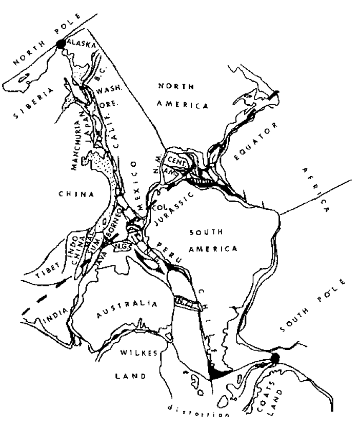  World Seafloors Detailed Map 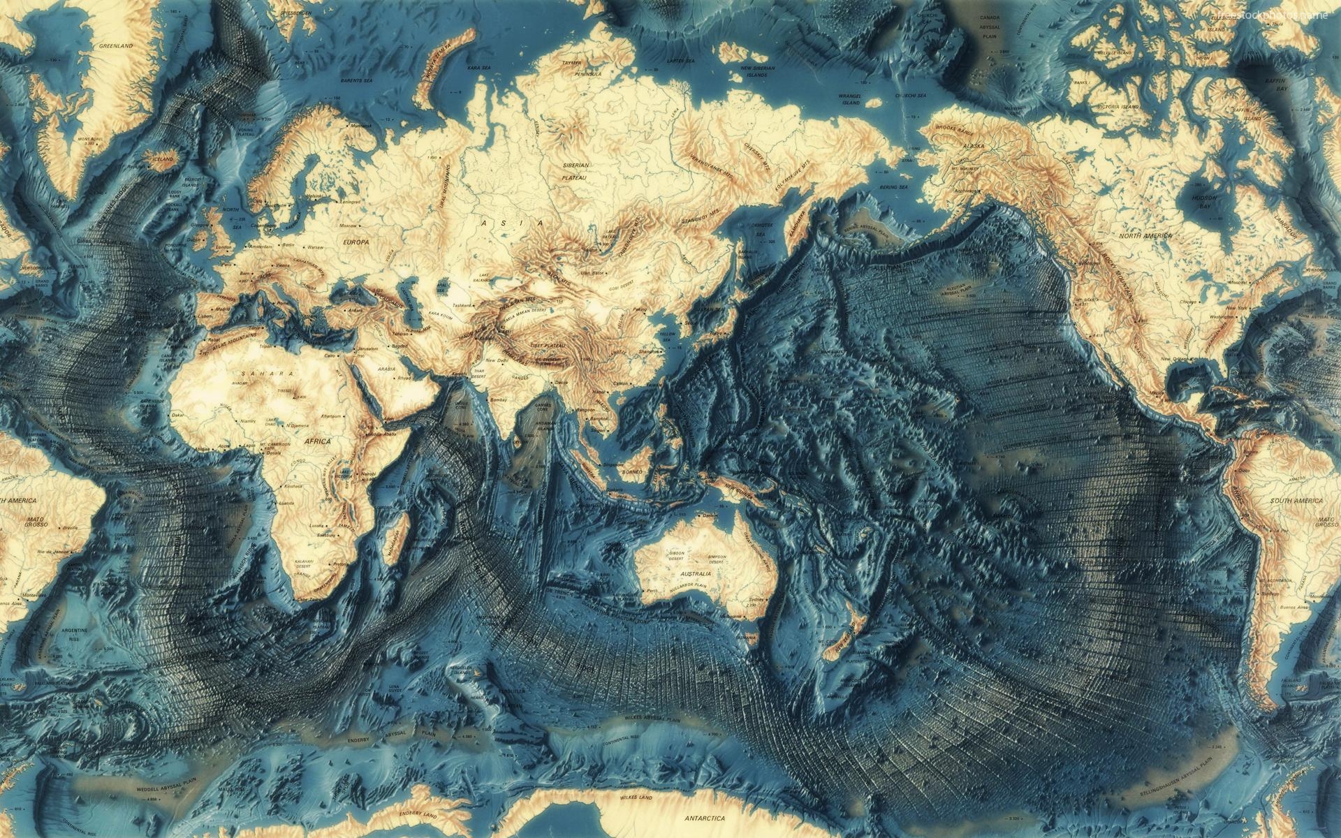  Re: Where are boundaries on Small Earth? Re: Where are boundaries on Small Earth?Saturday, January 13, 2018 5:48 PM From: "Eugene Ellis" <GeneAEllis@msn.com> To: "lkindr@yahoo.com" <lkindr@yahoo.com> Cc: "davidn@aoi.com.au" <davidn@aoi.com.au> "louis.hissink@bigpond.com" <louis.hissink@bigpond.com> "james.maxlow@bigpond.com" <james.maxlow@bigpond.com> _Lloyd, Hope this works. _The image you found connecting Australia to South America is misleading. Antarctica connects to S.A. leaving Australia coming down from Alaska. Wrapping Australia (on the white sheet of slide 9) appears as located on the flat NOAA map (a hemisphere of ocean away).   Lower image of Earth on the Left seems to be a bad copy of the Upper image on the Left. |
|
|
|
Post by Admin on Jan 18, 2018 1:01:56 GMT
10186 The Opening of the Pacific eugeneaellis Jan 16 4:00 AM _The key to opening the Pacific is the Antarctica-South America fit which places Australia + Zealandia close to Alaska. With this assemblage, Venezuela joins Baja California. _Global images are transposed on the NOAA- Age of the Ocean Floor flat map and do require some mental adjusting. It’s not perfect, but gives a rough idea of how growing continents separated and ascended over a 200 million year period as the radius of the Earth doubled. The ascent probably involves a quarter counter-clockwise twists. _They say a picture is worth a thousand words. Here are eight thousand unspoken words to start a conversation. _Go to: ionic-expanding-earth.weebly.com/opening-of-the-pacific.html _Scroll down for the slide show and click through the slides. _Gene Carl Strutinski Jan 16 4:33 AM _No, no, no! I must disappoint you. Your solution is the wrong solution. And how could you speak about "opening of the Pacific", beginning with a first slide in which the Western Pacific already exists??? The Western Pacific is the oldest part of the Pacific and it is this part of the ocean that requires an explanation of its coming into existence. Moreover, there is not a single argument to derive Australia from a region close to Alaska. A picture may be as well a fallacy as 1000 words. _Carl eugeneaellis Jan 16 5:44 AM _Carl, The first slide indicates Zealandia broke-up first. _Gene Michael Clark Jan 16 8:53 AM _Gene The reconstruction violates the simplified rules. _Continents move the minimum distance allowed to seperate them. _Continents rotate the minimum amount during motion. _New Land Can form that was not there previously. ( Mexico ) _The top of South America Plugs into the Gulf of Mexico ( Texas To Florida ) _The Bulb of Africa Plugs into the Appalacian Sea Board ( Florida to Maine ). _The right side of South America plugs into the left side Africa. ( Always the most obvious ) _The hard one to see is the top of South America plugging into Gulf of Mexico, because you have to mentally eliminate Mexico ( and Central America ). _MWC eugeneaellis Jan 16 11:41 AM _Mike, The reconstruction violates no simplified rules. On a smaller Earth, the continents move and rotate minimally. The note on Slide 5… ”Unfurling at the Gulf of Mexico” does not connote new land. _The rest is answered by this response made to the CNPS group: _I agree that some people can’t visualize how continents fit together from flat maps. Maybe it’s because they haven’t traced the continents from a globe and reassembled the pieces to make a smaller globe. My smaller globe, made from metal insect screens, is over 25 years old and sits on a shelf above me. The key is the Antarctica - South America fit which places Australia + Zealandia around Alaska with Venezuela joining Baja California. With this assemblage, Africa (on my flat map) does not fit the east coast of the U.S. One side fits while the other side distorts can be recognized and mentally adjusted when doubling the radius. _If you have a different vision or version, you should present it. I’m sure it would be welcomed. _Gene James Maxlow Jan 16 6:04 PM _Hi all, Your squabbling reminds me of plate tectonists. Reconstructions on a static radius earth model, regardless if it is a flat or round earth, is totally dependent on the number of researchers assembling the crusts. In other words, there are a multitude of plate-fit options coinciding with the number of researchers. _What Neal and I have been trying to tell you all, but without success it would seem, is that on an increasing radius earth model there is only one plate-fit option available for each of the oceans and time frames. The plate-fit is dictated by the seafloor crustal geology and is not governed by any rules other than if you move back in time you must return intruded seafloor volcanic lava back to the mantle and close off each of the oceans precisely as dictated by the MOR geology. There are no other rules. If your plate-fits disagree with each other then it is your plate-fit that are wrong, not the MOR geology. Anyone can reconstruct the oceans using the geology on small earth models and all will come out the same – for example, Neal, myself, and Klaus Vogel have each constructed small each models independently of each other using geological mapping and each reconstruction is essentially the same. _You can learn how to construct small earth models in my books and website at: www.expansiontectonics.com_Cheers, James Michael Clark Jan 17 at 11:06 AM _To put it more simply, the Ocean floors leave a pair of trails from the spreading ridge over to the edge of the continents. _It is like pulling a long sheet of Fabric attached to the edge of the continents out of the spreading ridge as the planets radius increases. Or, more like two sheets of fabric pulled out as both continents move away in oposite directions. The continents move the minimum amount allowed ( mostly vertical ) without any significant rotations. _The Vogel Globes, Maxlow 24, and Adams rotating globe all simulate the actual movement fairly well. _However, Continents do stretch, especially Western North America, when they remain too close to, or are positioned over a spreading ridge. _MWC Gene Ellis Jan 17 at 4:17 PM _To all, It is more than just plate reconstructions. It is when and how one rolls back the time and knowing what is causing the expansions. The Pacific fits gets into uncharted territory. If the reconstructions and timing are wrong, or partially wrong, then finding the cause would be equally wrong. So far, the small globe models have not convinced the scientific community or the general public. _Plate tectonics is wrong because we end up on a constant radius planet in an unexplained accelerating expanding universe. Once the Earth template is in place, the PT crowd will need to work out how to make the switch without losing their jobs, a long and time consuming process. Finding a cause for the heating and growing, both necessary for Earth expansions would hasten the process. _Gene Lloyd Kinder Jan 17 at 7:07 PM _Hi Gene. I'm afraid I disagree with Accelerating Expanding Universe theory. I believe John Kierein, Halton Arp and others have well shown that the Hubble Law is wrong and that the red shift is at least usually due to the Compton effect rather than Doppler. The high redshift quasar in front of a low redshift galaxy and Arp's finding of many similar quasars closely associated with similar galaxies disproves the Hubble Law. John says even the Sun is shown to have a Compton redshift. - Good Day. Lloyd 1.7-Billion-Year-Old Chunk of North America Found Sticking to Australia Wednesday, January 24, 2018 8:30 AM From: "Eugene Ellis" <GeneAEllis@msn.com> To: "lkindr@yahoo.com" <lkindr@yahoo.com> _Lloyd, Some new data connecting Australia to Canada. The P-T is wrong as well as the age. The connection is what you seek. www.livescience.com/61490-chunk-of-north-america-in-australia.htmlGene |
|
|
|
Post by Admin on Jan 19, 2018 3:23:51 GMT
lkindr Jan 17 4:57 PM _Hi Folks. I'm trying to get a clear picture of where the Pacific shoreline continents fit together on Small Earth. Does anyone have a link to such a picture/image? I've seen Gene's & James' images, but they're not clear. I copied James' images from his manuscript at cnps.boards.net/post/103/thread . It includes just the first two of his images of Earth with the N. Pacific opening up and the first three of the S. Pacific. _James, or anyone, regarding the Small Earth boundaries on those images, is the Ecuador area touching the N.E. Australia area? Is N.W. Australia touching the East Indies? And do the East Indies touch N. America? And regarding the S. Pacific, does Antarctica touch E. Australia? Does Antarctica touch S. America? And does N. central Australia touch N. America? _The image below James' images comes from somewhere online. It shows Alaska touching E. Siberia, Washington touching Kamchatka, Oregon & California touching Japan, Mexico touching China & Philippines, Colombia touching E. Mexico, Peru touching New Guinea, Chile touching Zealandia, Wilkes Land Antarctica touching S. Australia & Coats Land Antarctica touching Tierra del Fuego etc. Are any of those correct? _To get more accurate outlines of the continents, I found a Dymaxion world map at geospex.github.io/NSPE_Lectures_sp15/Class_4_Lecture/img/47c4.png __ And I found this site online where anyone can edit images free without registering or logging in: www.befunky.com/create . What's good about it is that images can be rotated any number of degrees. I have a Paint program, which does pretty good at everything besides the rotating. It only rotates images multiples of 90 degrees. _Once anyone comes up with a good fit of the Pacific continents, I want to see how close together on opposite shores we find matching fossils, geologic cross sections and living organisms. Is that so much to ask for? lkindr Jan 17 5:07 PM _Hi Gene. I'm afraid I disagree with Accelerating Expanding Universe theory. I believe John Kierein, Halton Arp and others have well shown that the Hubble Law is wrong and that the red shift is at least usually due to the Compton effect rather than Doppler. The high redshift quasar in front of a low redshift galaxy and Arp's finding of many similar quasars closely associated with similar galaxies disproves the Hubble Law. John says even the Sun is shown to have a Compton redshift. - Good Day. Lloyd James Maxlow Jan 17 6:00 PM _Hi Lloyd, Attached are two images of Australia and the Americas showing closure of the Pacific Ocean and the continental boundaries. Also shown on the first image are the locations of the ancient seas (these were plotted from published ancient coastline data). This particular image highlights the last remaining attachment of Queensland and California during the Triassic Period before separation during the Jurassic and draining of the Western Interior Seaway of North America. This coincides with the end-Triassic extinction event. (dashed lines represent submerged modern continental outlines). Note New Zealand to Mexico. Zealandia is submerged in the South Pacific Ocean. _The second image highlights the Australia, North and South America assemblage throughout the Palaeozoic and Precambrian times. No one will have anything remotely resembling this image. _Cheers, James 10211Red Shift/Big Bang Keith Wilson Jan. 18 at 7:55 AM _Recently Lloyd Kinder (LKINDER@...) has led made some interesting posts, in his attempt to reconstruct the Pacific. Just learned of this thru http:cnps.boards.net/post/103/thread. _In one such discussion was the Big Bang issue. It was mentioned the best alternative to the Doppler Effect Cause was "the Compton Effect", (of which I had not heard). Since I have followed Halton Arp and his disagreement with the Big Bang, I googled re Compton. I came across this www.plasma-universe.com/Redshift which lists many of the Red Shift causes and arguments that do not use the Doppler Effect so necessarily a part of the Big Bang. _I post this here for your potential interest and as a way I can recall it back in the future. Sincerely, _Keith Wilson Expanding Earth Knowledge www.EEarthK.comkpwilson1@... 612-296-4464 ET Atlantic (same as PT) www.wakingtimes.com/wp-content/uploads/2015/08/Expanding-Earth.jpgET Pacific () i2.wp.com/aetherforce.com/wp-content/uploads/2013/09/xearthheader1.jpg(NA/eAU+eAN) www.google.com/search?q=growing+earth&source=lnms&tbm=isch&sa=X&ved=0ahUKEwjC_aKSg-fYAhVEUKwKHXEpDekQ_AUICygC#imgrc=S74P2BKUycSeNM:ET Indian Ocean () magisapparatus.files.wordpress.com/2009/12/gindian.jpg(sIN/cMAD,nIN/HORN,wAN/seIN+sMAD+seAF,nAN/sAU,wAU/seAS) i.ytimg.com/vi/3Vplbdmqp4g/maxresdefault.jpg |
|
|
|
Post by Admin on Jan 23, 2018 2:39:25 GMT
10241Re: RE: [expanding_earth] The Opening of the Pacific
lkindr Jan 20 3:18 PM
_The quickest way I can think of to prove expansion is to show the same sort of data around the Pacific/Indian shorelines as Wegener and maybe others found around the Atlantic. I'm not trying to disprove expansion. If it's real, I want to see clear evidence. The magnetic patterns are evidence, but they're not strong evidence, since there are other theories that could also explain them. They don't necessarily indicate ages. They could have formed over short time spans etc.
10242RE: RE: [expanding_earth] The Opening of the Pacific
James Maxlow Jan 20 5:10 PM
_The ages of the magnetic patterns are determined by drilling down to the seafloor and taking samples of the rock at regular intervals across each of the ocean basins. The ages are determined by radiometrically dating the intruded basalt as well as dating the Nano-fossils from overlying sediments or sludge. The magnetic patterns record the lava intruded along each of the mid-ocean-rift zones over intervals of time – between 1 to 14 centimetres per year, and the linear patterns record the magnetic vectors acting on the magnetite crystals of the lava prior to cooling and solidifying. Age dating is used to date the linear magnetic anomalies detected during the magnetic survey, and hence add another dimension to the data. The relevance of the dating is only relevant to an earth increasing its radius over time, and basically is not, or cannot be used to quantify plate tectonics (which was the reason why the work was carried out in the first place – to quantify PT).
_James
10249 Re: RE: RE: [expanding_earth] The Opening of the Pacific
Carl Strutinski Jan 21 1:48 PM
_Some remarks on the magnetic patterns and the age of the oceanic crust:
The majority of magnetic anomaly data were collected through marine ship track, aeromagnetic, and helicopter surveys. They are almost independent of the rock samples taken from drilling. I shall give only two examples that should caution us about giving indubitable credit to these data.1) in the West Pacific it is considered mainly on interpretation of magnetic patterns, that the oldest upper crust is represented by basaltic flows of upper Jurassic age. However, on an immense area, of hundreds of thousands of square kilometers, which, according to magnetic lineations is considered to be covered by upper Jurassic MORB, in one single drilling (801C) MOR basalts of Jurassic age were drilled. In all other drilling sites from the region that reached basalts, these gave Cretaceous ages (lower or upper Cretaceous). Thus the age chart of oceanic seafloor seems to be at best of variable believability.
_2) Not all upper oceanic crust (except sediments) consists of MORB. In many places along the Atlantic and Indian ridges so called megamullions or oceanic core complexes (OCCs) were discovered covering areas of tens of square kilometers, that consist of upper mantle rock, like peridotite or gabbro. These evidently rose to the ocean bottom as solid rock, meaning that their magnetic minerals could not fix the time of their rising. Nevertheless, at some instances they also appear to show a magnetic lineation that can be traced continuously into the adjoining basaltic environment. So we can read in Wikipedia under the topic Oceanic core complex the following:
_"The conventional view that marine magnetic anomalies arose in the upper, extrusive layer of the oceanic crust requires a rethink because perfectly normal magnetic anomalies arise at core complexes, where the crust has been stripped away. This suggests that the lower part of the ocean crust contains a substantial magnetic signature."
_Carl
James Maxlow Jan 21 6:48 PM
_Not really sure what you are on about Carl. The examples you gave are relatively small percentages of the total areas exposed along the MORs and, of course, are interpreted and explained from a conventional PT perspective, not ET. Also, if you have mantle derived lava intruding mantle derived seafloor lava then the seafloor volcanic crust is actually exposed and quenched mantle – hence the presence of peridotite and gabbro.
_James
Michael Clark Jan 21 2:28 PM
_If there was no expansion and no additional ripping apart of the continents, then the width of each additional strip of ocean floor per equal unit of time would
increase exponentially. The increase in the width per unit of time would be predictable.
_However, when you look at James Maxlow's graph the shape of the graph has a double ski jump in it.
_The Impact at 66 Mya had a pronounced decrease in the rate of growth of the ocean floors which took many millions of years to recover from to again look like it is an exponential growth curve.
_If this same thing occurred at 252 MYa, and 438 to 439 MYa, and at 624 to 625 Mya, then the exponential growth of the Earth had numerous interruptions, with later recoveries.
_There would have been a Maximum of 23 Primary Impact induced interruptions in the Planets growth rate. There would also be many secondary interruptions
from impacts of far lower magnitude. Most would be too small to have any major effects. If there was one major Impact from each passage thru arms of the Milky Way Galaxy, there would be about 24 X 8 + 3 or 4.
_There would be a maximum of 195 to 196 Impacts of significant size to rattle the Earth, and potentially slow the Growth Rate. However, only about 5% to 10%
would be big enough to really Rattle the Earth and delay its growth rate.
_The delay in the growth rate occurs when the biggest impacts release lots of magma from inside the Earth and form flood Basalt areas that miles thick. The one at 66 MYA formed the Deccan Traps in Western India. The one at 252 Mya formed the Siberian Traps in Siberia. The Deccan Traps was enough to cover the current sized earth with a uniform layer of basalt 3 feet thick. The one in Siberia was thick enough to cover the current sized earth with a uniform layer of basalt 10 feet thick.
_Mike Clark
James Maxlow
Jan 21 6:52 PM
_Assuming, of course, that impacts had anything to do with emplacement of seafloor volcanic lava.
Carl Strutinski Jan 22 at 2:09 AM
_James, even though I do not share Storetvedt's view that magnetic lineations may have nothing to do with reversals of the magnetic poles, I am sceptical about attributing the age of the ocean floor in some parts of the world ocean exclusively on magnetic lineations. And I gave as example the Western Pacific, where a surface area almost equaling the USA is considered on magnetic lineations to be of Jurassic age (one single drilling intercepted radiometrically confirmed Jurassic basalt). The pattern of lineations (three sets of different oriented lineations) is problematic because it does not conform to the general accepted rule, that ALL oceanic crust has been formed along spreading ridges.
_I do not negate that Jurassic basalts may be present at deeper levels not reached by ocean drilling, but even in this case it is not plausible that they have formed due to the accepted model of spreading. Therefore I prefer to admit that there was a large zone corresponding to what has been addressed as Darwin Rise, that represented a mantle dome as a first manifestation of continental breakup. By the rising, which can be maintained geophysically, inside the upper part of this mantle wedge decompression melting occurred at numerous places, that gave rise to small extrusions taking place from the upper Jurassic to the late Cretaceous. These are now seen as seamounts littering the Darwin Rise, which for this reason is also known as the West Pacific Seamount Province (WPSP).
_Solid mantle pieces that ascended from beneath (diapirically?) are identified beside MOR basalts in the Atlantic and Indian Oceans in an ever growing number. As they may have been solidified hundreds of million years before the Jurassic, it is clear that they should have nothing in common with Jurassic magnetic lineations. So I would recommend to be careful with magnetic anomalies that may have more than one valid explanation.
I have not studied in greater detail other oceanic domains, but at least I suspect that the assumption that drilling or dredging of "samples of the rock at regular intervals across each of the ocean basins" is highly exaggerated.
_Carl
|
|
|
|
Post by Admin on Jan 23, 2018 4:17:47 GMT
eugeneaellis Jan 22 at 7:49 AM
_It seems geologist need and was seeking the cause of Earth expansion to answer the why of what is observed on the crust and others were sought to contribute. Instead, they got Geo-physicists who found subduction adequately filled the need and got the government’s help with the NOAA rainbow map echoing a consensus viewpoint while not disproving the observed expansion.
_Meanwhile, the sciences were busy addressing the bigger universe that was getting smaller by all the new discoveries, prompting the establishment of NASA to consolidate and explore new visions. The particle physicists established a Stand Model positing the universe consists of space, matter, and time. This universe, they believe consists of 4.9% ordinary matter (atoms), 28.8% dark matter, and 68.3% dark energy or numbers to that effect. The predictions, however, are based on a medieval assumption that matter is unchanging, e.g. atoms cannot change size. Einstein’s’ famous equation E = mc2 indicates…matter and energy are interchangeable. This is confusing; matter is unchanging but can be converted (created?) from energy? And, converting or creating isn’t changing the above percentages?
_This requires some critical thinking, so an old retired engineer from slower lower Delaware asks this simple question: How much of the 68.3% dark energy would be expended to convert the 28.8% dark matter to ordinary matter and if the remaining dark energy is (or is not) the heat energy producing the measured ~2.7 Kelvin temperature found permeating the universe?
_Gene
John D. Taylor Jan 22 at 6:14 PM
_"It seems geologist need and was seeking the cause of Earth expansion"
_Carey was a true scientist and one I consider great. You cannot read his works without admiring his sound reasoning and his devotion to an explanation which fits the evidence. There were times when he was handed what appeared as support and he analyzed and rejected it because to accept it would have taken him further a field from where the evidence pointed. Am thinking of his rejection of matter being compressed, which would allow for the mass needed for expansion. He rejected it because it would have caused surface gravity to be four times greater than present, precisely at a time when we had dinosaurs which seem improbable for living in our current gravity
_And for this very reason I think he would very much agree with Neal Adams that the matter can only be from new matter and would in fact be growth, but it would have been unwise for him to go there because he needed others to first examine the evidence of radius enlargement, not try to explain "growth".
_Which think most who have examined the evidence do see as the only viable option of the two, decompression or addition of mass.
_But that is a huge leap, one where you have to have so extensible examined the evidence you find it is the ONLY conclusion because if you double the radius of a sphere volume increases by EIGHT TIMES
_I know we are on a small planet but when you look around for material to support that GROWTH you pretty much come up empty, which is what Carey kept saying, it is something which would need to be explained by physicist because there is no source of material to supply it
_So all I can say is individuals who are true scientist willing to follow the evidence despite how impossible the conclusion are rare
_I have actually identified more possible ways to add mass than I have found individuals who are true scientist and James Maxlow is one of them. There are others but he does stand out as a profile in courage. He took a position in the very field which he needed to make a living to even eat, greatly admire him for it
|
|
|
|
Post by Admin on May 1, 2018 0:53:58 GMT
GROWING MATTER MODEL(See forums.naturalphilosophy.org/showthread.php?tid=502 ) 04-07-2018, 09:21 PM (This post was last modified: 04-07-2018, 10:04 PM by Lloyd Kinder.) _A. MAIN CLAIM: What is the main claim of GM theory? There was no Big Bang. 98.8% of Earth’s matter consists of 8 elements that started the planet, heated the planet, and has doubled the planet’s radius twice in less than a billion years. Slowing of Earth's rotation is due to mass and radius increase. _B. EARTH FORMATION: How and when did the Earth form? (Ga = billion years ago; Ma = million years ago; ka = thousand years ago) ~4.5 Ga (EARTH formed from) Dark Matter Conversion to 8 Elements _C. CRUST FORMATION: How and when did the largely granitic/sedimentary continents and the largely basaltic ocean basins form? ~200-0 Ma (Ocean CRUST formed from) Ocean Basin Expansion & some Continental Expansion _D. SEDIMENTARY STRATA: How and when did sedimentary rock strata form? ~1.4-0 Ga (STRATA formed from) Crustal Cooling in Layers _E. MOUNTAINS: How and when did mountains form? ~220-0 Ma (MOUNTAINS formed from) Increasing Earth Radius Curvature & Weathering
03-26-2018, 10:49 AM (This post was last modified: 03-26-2018, 10:57 AM by Lloyd Kinder.) Hi Gene. For peer review of your model, there are 4 requests below. The requests are part of the preliminary Summary Paper on Earth Theories at: forums.naturalphilosophy.org/showthread.php?tid=502Your information above may be helpful for the review after these 4 requests are answered. FOR the GROWING MATTER Model WE REQUEST: a. evidence of dark matter & of matter expansion via ionization potential b. an explanation of the dark matter to matter expansion mechanism and why it's probable c. confirmation that no other means of Earth's spin rate reduction, besides mass increase, such as electromagnetic braking, is probable d. a map showing where present Pacific boundaries adjoined on pre-expansion Small Earth & data showing similar biology & geology on adjoining areas. 04-06-2018, 09:01 AM Here's Gene's map. It shows the continental boundaries for the East Pacific, but not yet the West Pacific (Indonesia to Siberia) or the Indian Ocean area. .  upload jpg upload jpg
04-06-18 02:09 PM Hi Gene. As you probably noticed, I revised the Requests a little. I added the 2 Requests that I asked for all 3 Expansion models, which are a and b, but I added b later. Then c, d and e are what were labeled a, b and c above in your post. a. a more detailed map of small Earth showing: a1. where the original continental boundaries fit together a2. if rock & fossil types match near formerly adjoining boundaries a3. if trails are left on the seafloors that support the fit a4. where the continents may have morphed and if there's evidence of such morphing b. means to distinguish between Earth expansion & Earth morphing (See #5 ...). c. evidence of dark matter & of matter expansion via ionization potential d. an explanation of the dark matter to matter expansion mechanism and why it's probable e. confirmation that no other means of Earth's spin rate reduction, besides mass increase, such as electromagnetic braking, is probable. The purpose of the Requests, a and a1 was to prep for a2, 3 and 4. Your map above partly answers a1, but it doesn't show much detail of where the continents all adjoined on Small Earth. It's not clear where east Asia adjoined Indonesia or where south Asia adjoined Antarctica and South America. It's also unclear how southeast Africa fit into the picture. Would you like to try using the Dymaxion world map for continental shapes to try to fit together? Here's one: en.wikipedia.org/wiki/Dymaxion_map#/media/File:Dymaxion_projection.pngRegarding your last post above, do you claim that all matter starts out as dark matter? If so, do you have laboratory evidence of such dark matter? The only evidence I've heard of is the unexpectedly high velocities of stars in the outer part of the galaxy. But Charles Chandler's model of electrostatic repulsion seems to explain those velocities and almost everything else. Regarding Earth's spin rate reduction being caused by mass increase, could you supply here a few of your most important statements on that from your paper or from anywhere?
04-08-2018, 11:12 AM (This post was last modified: 04-08-2018, 11:34 AM by Eugene Ellis.) Gene Ellis response to Lloyd’s Growing Matter Model request. a. evidence of dark matter & of matter expansion via ionization potential Dark matter becomes ordinary elemental matter upon ionization for the first time. Dark oxygen existed until ~1400 mya, ionizing at 871.387 eV with a rate of decay of 1 eV/ 1.6 my (871.387 x 1.6 = 1,394 my). The IP is the measured energy level of an element having the potential to join other elements. Matter consists of energetic elemental masses. As the intrinsic energy of an element decays at a fixed rate, the energy converts to additional mass at specific times and to heating at other times. The heating period is an anomaly where a small incremental jump between the IPs of an element suddenly becomes a large jump. Heating is attributed to the anomaly since it adequately accounts for the tremendous amount of heat necessary to melt the large amount of iron that gravitated to the core during the first 3 to 3.5 billion years of earth’s existence. b. an explanation of the dark matter to matter expansion mechanism and why it's probable. Dark matter cannot grow, expand, heat, or join other elements until the first time it ionizes and becomes ordinary matter. Calcium was the first element to ionize ~8800 mya and hydrogen was the last ~22 mya. Only hydrogen, and possibly helium, was able to bond as dark matter with ionized elements. The mechanism for growing matter is the same mechanism that effects energy converting to mass in the equation E = mc2, except on a micro scale. Observing the photon is an example of pure energy at a higher level transforming to additional mass at a lower energy level. c. confirmation that no other means of Earth's spin rate reduction, besides mass increase, such as electromagnetic braking, is probable. The amount of energy that converts to mass to slow the spin of the earth one-half leap second per year is ~9.5 E+16 kg/yr. This translates to ~3 million electron volts per second or ~1.9 E+25 joules per second converting to ~3.3 million tons of mass per second. Similar quantities have not been demonstrated by electromagnetic breaking or any of the wave action models. d. a map showing where present Pacific boundaries adjoined on pre-expansion Small Earth & data showing similar biology & geology on adjoining areas. A slide presentation is here: ionic-expanding-earth.weebly.com/opening-of-the-pacific.htmlEvidence for The Opening of the Pacific is here: www.livescience.com/61490-chunk-of-north-america-in-australia.html The 1.7 billion year age of zircon is probably correct, but it cannot be the age or location of molten rock of that time. Tectonic plates and water were non-existent on the planet 1.7 bya thereby debunking the P-T theory. Additional Growing Matter items to consider: e. the origin of water. Upon the initial ionization of oxygen ~1400 mya, two dark atoms of hydrogen join to form water. Since then, water has been growing except when heating between 220 mya and 1200 mya. ionic-expanding-earth.weebly.com/origin-of-water-via-ionization.htmlf. debunking the dinosaur paradox. Reduced gravity of the past allows larger life sizes. At 50% gravity, the maximum dinosaur size is 24 tons. The fossil minerals that replaced the organic bone substances are growing matter. ionic-expanding-earth.weebly.com/dinosaurs.htmlg. debunking radiometric dating of ancient rocks. Radiometric dating of rocks does not involve consideration of when the rocks were in a molten state. Water formed and cooled a molten crust thereby limiting radiometric dating of archaic sedimentary rocks to 1.4 bya. No one could know the composition or location of molten rock a billion or two billion years earlier.
04-09-2018, 09:10 AM Gene Ellis: The Opening of the Pacific gets into uncharted territory. The key is the Antarctica-South America fit which places Australia+Zealandia around Alaska with Venezuela joining Baja California. This assemblage joins five of the eight continents together when the planet was roughly half its present size. Further clarifications where Asia adjoined Indonesia or where south Asia adjoined Antarctica and South America and how southeast Africa fit into the picture will follow, along with supporting evidence, once this new discovery is publicized. a.2 see previous link: (https://www.livescience.com/61490(chunk-of-north-america-in-australia.html) a3, a4, and b –No comment. Trails and morphing questions are better answered by geologist. c. laboratory evidence of dark matter is NBS-34, Ionization Potentials and Ionization Limits Derived From the Analysis of Optical Spectra. Any energy exceeding the highest IP level listed indicates such element is undetectable and existed as dark matter from the time of its inception. All the elements have ionized; hence, there is no remaining dark matter when considering all matter in the universe consists of elemental atoms. Spin rate reduction and leap seconds quantifying Earth’s growing mass are on the opening page and in the discussion on page 4 of the Growing Earth / Expanding Universe (GE/EU) paper: ionic-expanding-earth.weebly.com/growing-earthexpanding-universe.htmlJack Hohner, on page 15 of his paper: dynamicmatter.com/wp-content/uploads/2016/10/DEFICIENCIES-IN-TIDAL-FRICTION-rev1.pdf, calculates 5.68523302 E 16 kg/yr mass increases while conserving angular momentum by using a completely different method. This compares favorably to the ~9.5 E 16 kg/yr calculations using the leap second. Some interesting points are surmised when comparing the sizes of Earth from James Maxlow’s book Beyond Plate Tectonics with the Ionic Growing Earth data. When the radii from both are plotted as in the chart below, it is noted that the differences in size until ~250 mya can generally be attributed to the growing continents. The surface gravity and radius for the same time period can readily be determined for both without a lot of complicated math. A halving of the radius or gravity is indicated at 50%. The differences between 250 mya and 600 mya are likely due to the size of the primordial radius, 1700 km versus 800 km, and the time when exponential expansion effectively began. A second halving of the radius is indicated on the IGE curve at 25% around 470 mya. A second halving is not possible with a 1700 km primordial radius.
04-09-2018, 10:15 AM (This post was last modified: 04-10-2018, 09:32 PM by Lloyd Kinder.) Gene, your first link didn't work, because there was a parenthesis mark instead of a dash in it. Here's what it should be (without the space after http://www.): https://www. livescience.com/61490-chunk-of-north-america-in-australia.html Here's the map from that article. img.purch.com/h/1400/aHR0cDovL3d3dy5saXZlc2NpZW5jZS5jb20vaW1hZ2VzL2kvMDAwLzA5Ny85MTkvb3JpZ2luYWwvc3VwZXJjb250aW5lbnQtbnVuYS5qcGc=Here's your graph which apparently shows your and James' figures on Earth's dimensions through previous geological time periods till now. Gene, can you tell us where this data is from?  Here's a CNPS video of Maxlow's model www.youtube.com/watch?v=P38eReiw7LUGene's and James' models seem to start Australia, Antarctica etc out differently. David Noel was one of the models in the Special Project #2 and is shown in the Summary paper. Gene shows constant density during expansion. I guess James probably shows about that too. David seems to say that mass didn't increase, just volume did, via neutronium expansion. I think the first two would entail weaker gravity at the surface in the past, which is more consistent with former megafauna and megaflora. (But I think thicker atmosphere is what accounts for that.)
04-09-2018, 04:35 PM Lloyd, The graph would be under my last comment if you removed the Live Science link and map as requested. It says: Some interesting points are surmised when comparing the sizes of Earth from James Maxlow’s book Beyond Plate Tectonics with the Ionic Growing Earth data. When the radii from both are plotted as in the chart below, it is noted that the differences in size until ~250 mya can generally be attributed to the growing continents. The surface gravity and radius for the same time period can readily be determined for both without a lot of complicated math. A halving of the radius or gravity is indicated at 50%. The differences between 250 mya and 600 mya are likely due to the size of the primordial radius, 1700 km versus 800 km, and the time when exponential expansion effectively began. A second halving of the radius is indicated on the IGE curve at 25% around 470 mya. A second halving is not possible with a 1700 km primordial radius.
04-12-2018, 10:45 PM (This post was last modified: 04-12-2018, 10:48 PM by Lloyd Kinder.) POSSIBLE CAUSE OF REDUCED SPEED OF EARTH ROTATIONNature Unbound VII – Climate change mechanisms judithcurry.com/2018/01/21/nature-unbound-vii-climate-change-mechanisms/Climate variations that alter the angular momentum of the atmosphere modify the speed of the Earth’s rotation, which affects the length of day (LOD). Alterations in LOD integrate different climate-affecting phenomena, and can anticipate turning points in climate.
Eugene Ellis 04-15-2018, 06:11 PM The leap second represents a slowing of Earth’s rotational velocity (spin) by losing approximately one-half second over a yearly period of 31,557,600 seconds. The current mathematical model was derived from LOD (length of day) work by Stephenson and Morrison and is based upon a solar day equaling 86,400 seconds. This model wrongly attributes the slow down to tidal friction and possibly a redistribution of Earth’s internal mass, all of which presume a constant mass with some questionable transference of energy and momentum to change orbital motion. Citing climate changes as a possible cause of reduced speed of Earth’s rotation only complements the solar day model.
|
|
|
|
Post by Admin on May 5, 2018 16:28:43 GMT
Re: CNPS Project Summary Wednesday, May 2, 2018 4:30 AM From: "David Noel" <davidn@aoi.com.au> To: "lloyd kinder" <lkindr@yahoo.com> Raw Message Printable View Hi Lloyd -- -- In answer to your request for information on my models of the Earth: ------------ 1. how and when the Earth formed? 2. how and when the Earth's continental crust formed? 3. how and when the Earth's oceanic crust formed? 4. how and when mountains formed? _For anything your model doesn't cover, you can say N/A for not applicable, or leave blank etc. _Also (in about 35 words or less in each case) we request: a. evidence of neutronium & its expansion b. explanation of the neutronium expansion mechanism and why it's probable c. a map showing where present Pacific boundaries adjoined on pre-expansion Small Earth & data showing similar biology & geology on theorized formerly adjoining areas. ----------- (1. how and when the Earth formed? ) The Earth, and most of the other Solar System bodies, formed about 4.8 billion years ago, by aggregation of matter in interstellar space, as part of the local Oort Soup. See "P1: The Cosmic Smog model for solar system formation, and the nature of 'Dark Matter' " at <http://www.aoi.com.au/bcw1/Cosmic/index.htm>. (2. how and when the Earth's continental crust formed?) The Crust, the outer-surface of the new planet, was formed at the same time. No molten phase is assumed. The Crust is essentially MORB (outer-Mantle material) which has been continually reworked (by Earth-Expansion processes) ever since formation. (3. how and when the Earth's oceanic crust formed?) Oceanic crust is essentially MORB which has not been fundamentally re-worked. It has always been present on the Earth, below the Crust of the time, but was first widely exposed about 200 million years ago, when Earth-Expansion stretched and broke up Pangaea to expose unworked surface. (4. how and when mountains formed?) Linear ranges of mountains were formed by friction between Earth-Domain edges as these domains underwent relative displacement during Earth-Expansion. Other mountains and elevated plateaus such as in Tibet are essentially mesas, the remains of weathering of elevated plains, not upthrust but just left behind as other areas of the Earth sank relative to them due to differential expansion effects. (a. evidence of neutronium & its expansion) My model assumes that during the initial aggregation process as in (1), gravitational forces cause bodies above a certain mass threshold (mass of Mars and above) to accumulate compressed-neutron-rich cores, with larger cores for more massive bodies. This applies for Mars-size and above, not only planets but also sub-stars and stars. These cores are not necessarily just neutrons, although for stars which have gone supernova and thrown off their outer layers, they may leave behind a core which is mostly neutrons (neutron star). This model gives a quantitative explanation of the inner heat levels of the Solar System planets, and a new insight into stellar processes. No other model known to me explains the full range. The fact that unrestrained neutrons decay into a proton and an electron, with release of energy and a half-life of about 10 minutes, is very well established. When a proton and a free electron combine to give a hydrogen atom, that atom is about 300 trillion times the volume of the neutron it came from. <EP303: The Earth-Expansion Model Part B -- Answers to A Hundred Puzzles: www.aoi.com.au/EP/EP303.htm/>. This is not in dispute. (b. explanation of the neutronium expansion mechanism and why it's probable) This is given in "Inside The Earth -- The Heartfire Model", <http://www.aoi.com.au/bcw/Heartfire/index.htm>. (c. a map showing where present Pacific boundaries adjoined on pre-expansion Small Earth & data showing similar biology & geology on theorized formerly adjoining areas) There are plenty of such maps in "The Distributions Of Nut Trees [NU004]", <http://www.aoi.com.au/NUSite/NU004.htm>. ...... Cheers, David. |
|
|
|
Post by ovozoyig on May 11, 2019 6:16:50 GMT
|
|
|
|
Post by atifeyasa on May 11, 2019 8:26:57 GMT
|
|
|
|
Post by edilujepure on May 25, 2019 19:54:23 GMT
|
|
